At the Australian census of 1881, Tasmania was recorded as having a population of 115,705. Of these, 21,118 people lived in Hobart. Hobart was by this time an established city, the capital of the island state, with elegant sandstone buildings and the same well functioning institutions found in Britain: Parliament, Courts and a gaol, cathedrals and churches, hospitals, theatres, schools and a university, a museum, a Royal Society and Botanic Gardens as well as those organizations of private citizens that assisted in making the city a civil place.
One visitor to Hobart Town in 1871 had described it as ‘unquestionably the “Queen City” of the South in point of natural beauty’. Even Sydney could not ‘bear comparison with the grandeur and picturesqueness of that glorious estuary and river, bold to ruggedness to commence with, alternately breaking away into innumerable bays, and as suddenly closing into narrows, whose lofty promontories and jutting crags frown down in solemn grandeur, till at last it settles into the serenity of an inland lake, closed in by hills, with the city spreading out at the foot of Mount Wellington, that rears its gigantic pinnacle as a background 4,500 feet above the level of the sea’.
Despite the wide streets and fine buildings, there were also the ubiquitous public houses on nearly every block. There was poverty too, with people living in slum conditions particularly near the docks and in pockets on the edges of the city. It is among these people that my novel Cold Blows the Wind is set. The map below shows the streets where the characters in my novel walked as well as the location of the places they lived, the institutions they interacted with and some of the impressive buildings that dominated Hobart’s streetscape.

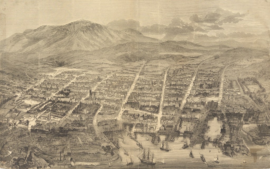
As can be seen from the next map – a ‘balloon’s view’ of Hobart – by 1894 the city had spread further out, with a population increase of 3,787 from 1881 to 1891. Although this map was drawn nearly ten years after the end of the novel, as a pictorial map it is useful in showing the extent of Hobart and its proximity to the surrounding countryside as well as an idea of how built up the central area of the city was. It also provides an excellent sense of the presence of awe inspiring Mount Wellington.

1 – Locations around Upper Liverpool
& Molle Streets.
A large part of the novel takes place in and around the upper end of Liverpool Street. There was a mixture of housing in the area, some houses were well made and quite expensive, some were less salubrious but within the reach of working families and others were best described as slums. The area had the advantage of being on higher ground and less prone to the flooding that frequently occurred in the Wapping area near the docks and the outlet of the Hobart Rivulet. Although near the edge of the city at this stage, it would only take around twenty minutes to walk from Molle Street down to, say, Peacocks jam factory on Old Wharf (Hunter Street).
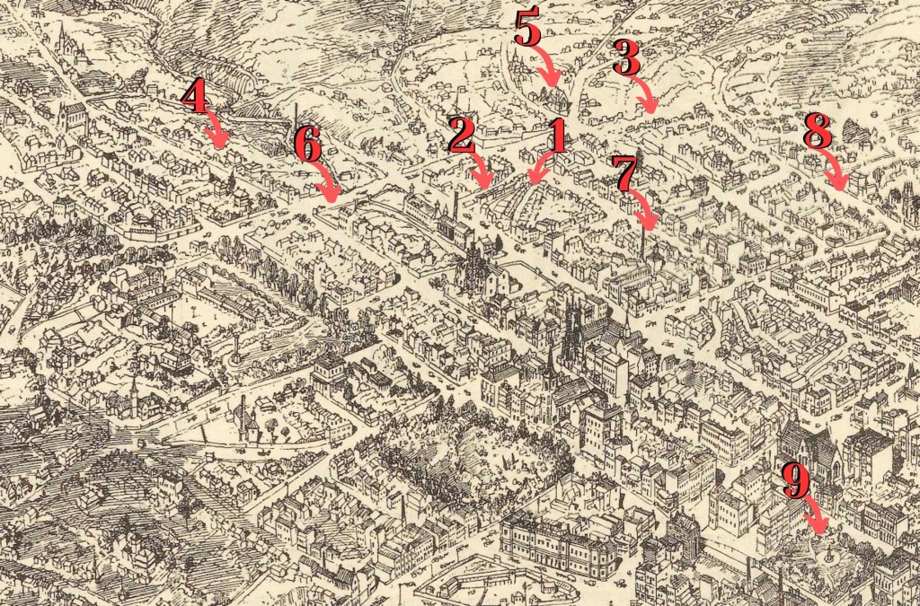
1 – Moodie’s Row
2 – Watchouse Lane
3 – Molle Street. Ellen and her family lived in the section of the street.
4 – Upper Macquarie Street. The Thompson family lived in Denison Lane off Upper Macquarie Street from 1880.
5 – All Saints Church
6 – Molle Street
7 – Liverpool Street
8 – Bathurst Street
9 – Franklin Square
I recently discovered this photograph of Liverpool Street which gives a glimpse of Watchhouse Lane and some of the the small houses in Moodie’s Row.

2 – Locations near Lower Macquarie
& Campbell Streets
The area surrounding the lower end of Macquarie Street was unofficially known as Wapping, after the similar dockside area in London. It was a crowded working class area close to the wharves, markets and factories such as tanneries, soap and candle manufacturers and Peacock’s jam factory where many of the inhabitants worked. The gasworks, railway yard and slaughter yards were nearby. Rents were cheap and there were numerous boarding houses as well as the pubs and theatres that attracted whalers and other seamen straight off their ships looking for entertainment to celebrate the end of a voyage.

1 – Creswell’s Row where Mary Ann Thompson, Ellen’s elder sister lived.
2 – Old Wharf was the location of Peacock’s Jam Factory.
3 – The General Hospital
4 – The Campbell Street Gaol and House of Correction
The large building in the bottom right was built in the Queen’s Domain for the Tasmanian International Exhibition held in Hobart in 1894-5.
3 – The Elizabeth Street Pier & Franklin Square

1 – Elizabeth Street Pier with steamer, possibly the SS Southern Cross alongside.
2 – Franklin Square bounded by Davey, Elizabeth and Macquarie Streets.
3 – Tasmanian Steam Navigation Co. offices
4 – Old Wharf.
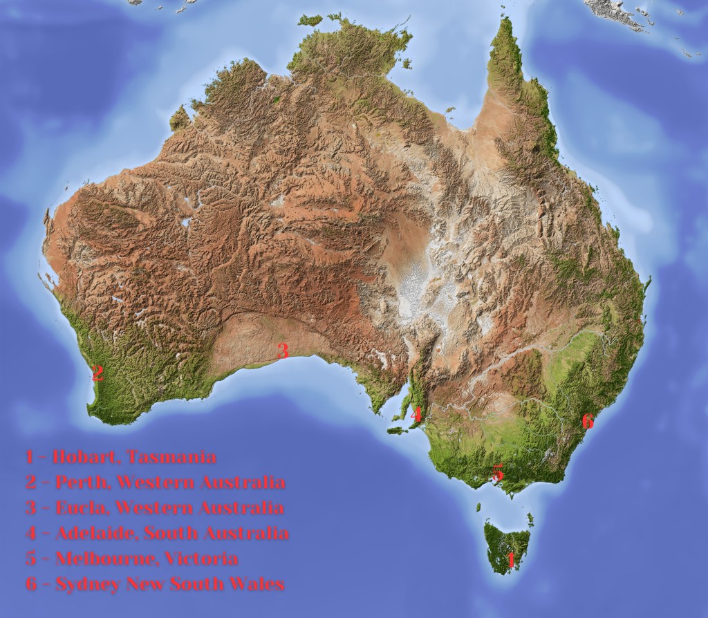
And for those unfamiliar with Australia, here are the locations of the cities and towns outside Tasmania mentioned in Cold Blows the Wind.
______________________________________________________________
Images
Hobart Town 1879
[Hobart Town] A.C. Cooke, delt. (1879), SD_ILS:94421 Courtesy the Allport Library and Museum of Fine Arts, State Library of Tasmania. [Balloon’s eye view of Hobart Town by A.C. Cooke from The Australasian sketcher with pen and pencil, 10 May 1879]
Hobart 1894
A bird’s-eye view of Hobart, Tasmania (1894), SD_ILS:920758 Courtesy the Allport Library and Museum of Fine Arts, State Library of Tasmania. [A bird’s-eye view of Hobart, Tasmania from Australian Town and Country Journal, 17 Nov 1894, pp.26-7. Key to image on p.28]
Moodie’s Row and Watchhouse Lane
Part of Hobart from album ‘Tasmanian Scenes’. Courtesy Mitchell Library, State Library of New South Wales.
Map of Australia
Australia. Shaded relief map with major urban areas. Licenced via Shutterstock. Image contributed by AridOcean

This was fascinating reading, Catherine.
LikeLike
Thank you, Barbara. I love maps, particularly pictorial maps. They are never completely accurate but they do give you a good sense of the place. I’ve been so fortunate, too, in the number of photographs of 19th century Hobart that are available online. So useful in helping me step back as Hobart, like most modern cities, has lost many of the old buildings, though the big public buildings and the churches remain.
LikeLike